5.2 CBR Cycle Routes
SUBMISSION
Next 5.3 Cycle highways
The official signed cycle routes between Canberra’s town centres are branded CBR Cycle Routes. What we see today is part of a large network of cycle routes, some have not been built yet or only in part. In the Active Travel Framework and Active Travel Standards, the CBR Cycle Routes providing connections between town centres are known as Principal Community Routes. Local Community Routes are planned within suburbs to destinations such as schools and shops.
The online Active Travel Infrastructure Practitioner Tool (see Section 5.4) is an urban planning tool, “created to provide timely route information for planners, developers and facility designers.” The Active Travel Infrastructure Practitioner Tool shows both existing and intended Community Routes.
Issues with the Active Travel Infrastructure Practitioner Tool are discussed in Section 5.5.
The Plan
The CBR Cycle Routes are represented on a “London Metro” styled map. Figure 5-1 is an enlargement of the map showing the CBR Cycle Route C5 between Coombs and the zoo.

Figure 5-1 CBR Cycle Routes enlargement C5 and C10, Active Travel Infrastructure Practitioner Tool
| Route | Name |
|---|---|
| C1 | City - Gungahlin |
| C2 | City - Queanbeyan |
| C3a | City - Belconne via Town Centre |
| C3b | City - Belconnen Town Centre Bypass |
| C4 | City - Tuggeranong via Woden |
| C5 | Belconnen - Tuggeranong via Weston Creek |
| C6 | ANU - Dickson |
| C7 | Belconnen - Gunhalin |
| C8 | City Loop |
| C9 | Gungahlin - Fyshwick via Airport |
| C10 | Future City - Molonglo |
| C11 | Future City - Gungahlin via Dickson |
| C12 | Future City - Molonglo via Parlimentary Zone |
| LBG | Lake Burley Griffin Circuit |
| Table 5-1 with same information replacing Figure 5-2 CBR Cycle Routes index, Building an Integrated Transport Network Active Travel 2015, ACT Government, 51. |
The complete network of CBR Cycle Routes is shown in Figure 5-3 from the active travel document Building an integrated transport network: active travel (2015). This map exists in many versions. Figure 5-3 shows both existing and planned (future) routes.

Figure 5-3 CBR Cycle Routes, Building an integrated transport network active travel 2015, ACT Government, 51.
The online tool
Here is a brief introduction to the Active Travel Infrastructure Practitioner Tool (ATIPT) . Section 5.4 provides a more complete description.
The map in Figure 5-3 shows only cycle routes, however, ACT transport planning includes many other transport networks for other user groups. The Active Travel Infrastructure Practitioner Tool is an online interactive map that shows all route types. The data is derived from the ACT Government planning tool ACTmapi.

Figure 5-4 Menu Active Travel Infrastructure Practitioner Tool
Community routes are a hierarchy of Principal, Main and Local Community Routes. As this is a planning tool, not all the paths currently exist. The tool includes the planning status: endorsed, intended and future. Endorsed plans are signed off, intended are likely to eventuate, and future, well,… who knows.

Figure 5-5 Community Routes, Active Travel Infrastructure Practitioner Tool
Two further types, Accessible Pedestrian Routes (wheelchairs, no bikes) and On-Road Cycling Routes (cycle lanes), are worth mentioning.

Figure 5-6 Accessible Pedestrian Routes (no bikes) and On-Road Cycling Routes, Active Travel Infrastructure Practitioner Tool
Destinations in the Active Travel Framework are places we ride to, including shopping centres and schools.

Figure 5-7 Town and group centres, Active Travel Infrastructure Practitioner Tool
We need to ride across roads safely. Special facilities are provided at these points in the network as conflict with motor vehicles a common issue. Two common types are zebra (wombat) crossings and path priority crossings. Zebra crossings are laid out for pedestrians, but cyclists can use them t00. Path Priority crossings, found on Main Community Routes, are optimised for cyclists to give them priority over cars (note the give way sign).
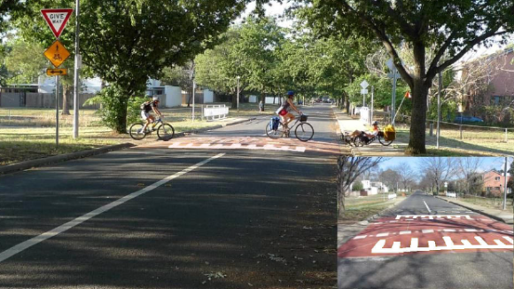
Figure 5-8 Path Priority crossing of a Local Access Street Location: Lyneham, ACT. Inset detail shows crossing area speed hump and ACT linemarking detail. 2019 Active Travel Facilities Design Municipal Infrastructure Standards 05, 56.

Figure 5.9 Lights, underpasses, zebra and priority crossing, Active Travel Infrastructure Practitioner Tool
Next 5.3 Cycle highways